By Brian J. Pape, AIA
Wikipedia provides background information about previous attempts at sea barriers.
The Thames Barrier is a retractable barrier system that is designed to prevent the floodplain of most of Greater London from being flooded by exceptionally high tides and storm surges moving up from the North Sea (#1 below). More modestly-sized but still highly effective storm-surge barriers have been in operation for nearly half a century in three New England communities. Examples below are the Stamford Hurricane Protection Barrier in Stamford, Conn. (#2); the Fox Point Hurricane Barrier in Providence, R.I. (#3); the New Bedford Harbor Hurricane Barrier in New Bedford, Mass. (#4). This article will also review other flood barrier systems.
#1. The famous Thames Barrier work began at the site in 1974 and was completed on October 31, 1982. The barrier protects the heart of London from flood devastation and is typically deployed up to 12 times per year. It is closed (raised) during high tide; at low tide it can be opened to restore the river’s flow toward the sea.
As of November 2021, there have been 201 flood defense closures. The barrier has survived 15 boat collisions without serious damage. Recent analysis determined the working life of the barrier will last until 2060–2070. The Greater London Authority is currently studying proposals to strengthen its defenses. Released in 2005, a study by four academics contained a proposal to supersede the Thames Barrier with a more ambitious 16 km-long (10 mi) barrier across the Thames Estuary.

#2. The Stamford Hurricane Barrier provides protection for about 600 acres, which include principal manufacturing plants, a portion of the main commercial district, and residential sections.
Stamford has been subject to heavy losses from storm tidal flooding since 1635. The September 1938 hurricane resulted in losses of almost $6 million to the project area. In 1954 Hurricane Carol caused $3.4 million in damage, $2.9 million of which could have been saved if a hurricane barrier had existed at that time.
In 1938 the area was severely flooded by a hurricane that swept through southern New England. Since then, barriers have been constructed in Stamford Harbor to prevent similar flooding. About 600 acres of downtown Stamford is now protected by a two-mile-long barrier system, built in 1969 by the Army Corps of Engineers, that helped prevent about $25 million in damage during the 2012 flood storm surge of Hurricane Sandy. Construction of this project started in May, 1965, and ended in January, 1969. The city operates and maintains the Stamford Hurricane Protection Barrier, with the exception of the navigation gates which are operated and maintained by the Corps. The project prevented $38.4 million of flood and coastal storm damages as of September 2011, while only costing $14.5 million to build.
Hours before Hurricane Sandy struck Stamford in 2012, the city’s 17-foot high movable barrier was closed to withstand the storm tide higher than 11 feet that struck western Long Island Sound (at some locations on the Sound the storm tide was even higher than the 11.5-foot tide measured at The Battery in New York City) and devastating every waterfront community on the northwestern coast of the Sound—except Stamford.
#3. The Fox Point Hurricane Barrier is a 3,000-foot-long (910 mi) tidal flood barrier spanning the Providence River in Providence, Rhode Island. It was constructed between 1960 and 1966 to protect the low-lying downtown area of the city from damaging storm surges and floods associated with hurricanes and other major storm events.
In September 1938 the Great New England Hurricane slammed the coast of southern New England, killing 250 people and causing millions of dollars in damage. Downtown Providence was entirely submerged under water, causing about $120 million in damage. In 1954 the area was hit by Hurricane Carol, which produced an even higher storm surge of 14.4 feet above mean sea level, that resulted in over $41 million in damage.
The Fox Point Hurricane Barrier is the first of its kind in the U.S., and consists of five main parts: river gates, rock and earthen dikes along each shore, vehicular gates along each shore, canal gates associated with the electric power station, and a pumping station. The $16 million wall has not yet been subjected to a category 5 hurricane, but has successfully protected the city in every instance since its construction. The savings has been estimated at several hundred million dollars, and the project operates at a cost-benefit ratio of 2.21 to 1.

#4. At the start of early America, the New Bedford Harbor provided European settlers the basic essentials—water, food, travel—and more. The success of the earliest communities depended on this river. The New Bedford Harbor Hurricane Barrier was built on the New Bedford coast, beginning in 1958. It consists of an arc of riprap and fill, approximately three kilometers long, surmounted by a service road. At the center of the marine structure is a control tower and a set of hydraulically operated doors that can be closed, when necessary, to shut out the surge of seawater that typically accompanies a major storm or hurricane. Taken as a whole, the barrier is the largest stone structure on the east coast of the United States.
The 20-foot high barrier continues onto land, where three large doors allow street traffic to pass through when the sea is calm. The longer segment continues along the New Bedford coast to just before Frederick Street. A discontinuous segment protects the top of Clark’s Cove in New Bedford, roughly, to the Dartmouth border.

#5. The Saint Petersburg Flood Prevention Facility Complex (dam) spans the Gulf of Finland, with the island of Kronstadt at its center. It extends 25.4 km (15.8 mi) and stands 8 m (26 ft) above sea level. It incorporates two large openings for shipping, which can be closed when floods threaten. Construction began in 1979 but stalled during the Russian political and economic upheavals of the 1990s; it resumed many years later and finally finished in 2011. Interestingly, the main benefit that most people cite is not flood control, but, rather, improved traffic flow, as the dam completes the Saint Petersburg Ring Road.

#6. Others
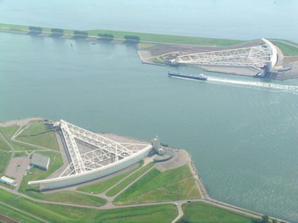
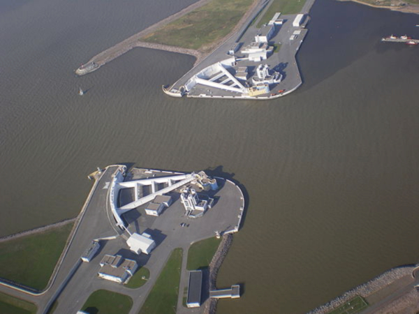
Larger barrier systems, that protect more than a dozen major cities, include the Delta Works that protects the south of the Netherlands, and the MOSE Project that protects Venice. New storm-surge barriers on Lake Borgne and Lake Pontchartrain are part of the protection provided for New Orleans after Hurricane Katrina.
The NY harbor sea wall is going to be much larger than any of these precedents, but the concept is well-established. Instead of piecemeal attempts to protect individual scattered properties, the idea of protecting an entire region is the only reasonable approach.
Brian J. Pape is a LEED-AP “green” architect consulting in private practice. He serves on the Manhattan District 2 Community Board Landmarks Committee and Quality of Life Committee, and is also co-chair of the American Institute of Architects NY Design for Aging Committee, a member of AIANY Historic Buildings Committee, and a journalist specializing in architecture subjects.